Geospatial decision support
Valencia Bike Equity
Open municipal data, spatial accessibility, multi-criteria robustness and counterfactual planning in one transparent workflow.
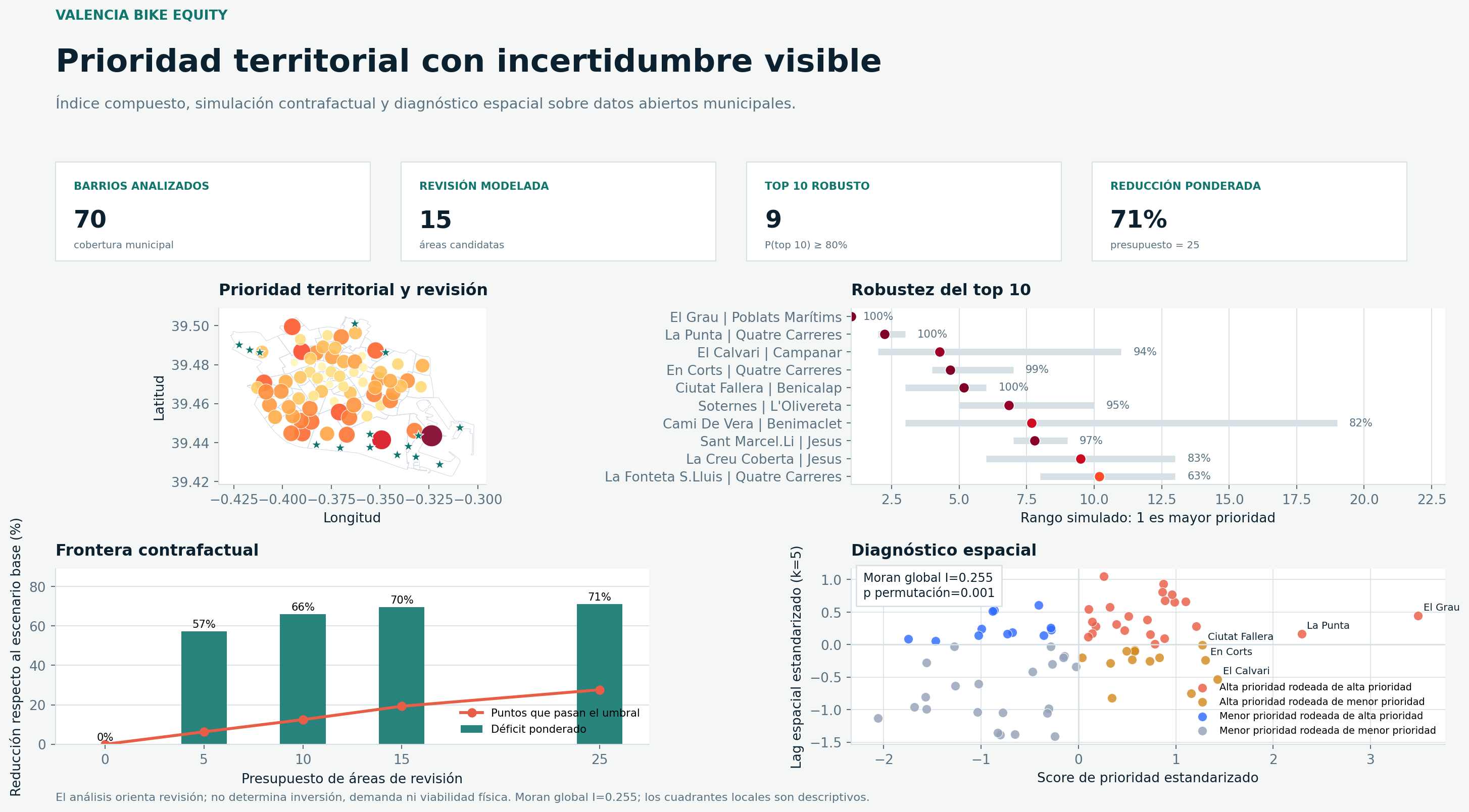
Measured project results
- parking points processed
- 4,316
- MCDA weight scenarios
- 10,000
- modeled distance-deficit reduction
- 71.0%
- global Moran permutation test
- p = 0.001
Metrics come from the committed reproducible run in the linked repository. Their interpretation and limits are documented below.
Architecture
System flow and reviewable outputs.
- 01
Versioned municipal snapshots
- 02
Schema and CRS validation
- 03
Projected accessibility analysis
- 04
MCDA robustness and Moran diagnostics
- 05
Counterfactual planning artifacts
Reviewable artifacts
- Offline snapshot
- Spatial diagnostics
- MCDA simulation
- Streamlit dashboard
- Tests and CI
Technology stack
- Python
- Shapely
- pyproj
- Plotly
- Streamlit
- pytest
Question
What the project investigates.
A wide parking network does not guarantee comparable coverage between neighborhoods. The analysis asks where vulnerability, capacity and accessibility deficits persist together, without turning modeled outputs into construction recommendations.
Approach
Method, in order.
- 01
Normalize public snapshots and preserve provenance with SHA-256 manifests.
- 02
Build 300 m diagnostic and 150 m planning grids in a projected local coordinate system.
- 03
Score neighborhoods with transparent MCDA and test rankings through 10,000 Dirichlet weight scenarios.
- 04
Measure global spatial autocorrelation with 999 permutations and inspect descriptive quadrants.
- 05
Compare constrained review-area portfolios through a greedy coverage frontier.
Evidence
Results with context.
- 70 neighborhoods and 617 diagnostic grid points are included in the reproducible snapshot.
- EL GRAU holds rank 1 in all 10,000 sampled weight scenarios; nine neighborhoods have at least an 80% top-10 probability.
- The 25-area counterfactual portfolio brings 179 planning cells below the 250 m threshold.
Quality controls
How the work can be reviewed.
- Snapshot-based execution works without a network connection.
- Pytest, Ruff and GitHub Actions reconstruct the analysis from committed inputs.
- Decision model, data dictionary and methodology document assumptions and boundaries.
Limits
What the output is not.
- Straight-line distance is not a cycling route or a street-level feasibility study.
- The score is not demand, cost, occupancy or causal impact.
- Counterfactual areas are modeled screening points, not investment proposals.